From Field to Map: How Soil Names Took Shape
Soil classification turns varied ground into shared names, helping readers compare maps while recognising what a category can—and cannot—tell them.
The common mistake with soil names is to treat a map label as a complete description of the ground beneath your feet. Soil classification makes places easier to compare, but a broad category can hide local changes in texture, drainage and depth—the details that matter when you walk a field or interpret a landscape.
Why did people start naming soils?
People needed a shared vocabulary for ground that behaved differently. A farmer might describe a field by how it worked under a plough; a surveyor might record its layers; a mapmaker needed terms that could be applied consistently across a region. Soil names grew from these practical needs, not from a single act of naming.
At first, descriptions often relied on what was readily noticed: colour, feel, stones, wetness and the plants growing above. Such observations remain useful. Dark, crumbly material may suggest abundant organic matter, while a pale, gritty surface can feel quite unlike sticky, fine-textured ground. But appearance alone cannot establish how a soil formed or what lies beneath it.
As descriptions became more systematic, observers began grouping soils by recurring combinations of features. Shared categories let a reader compare one area with another, even when the people who mapped them had never visited the same field. The name became a compact record of observations and interpretation.
How did field observations become soil categories?
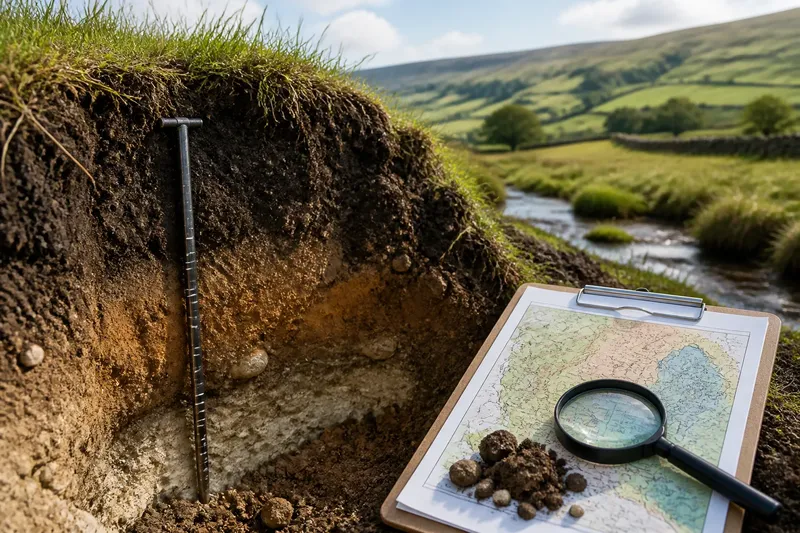
A soil profile gave classification a more dependable basis than surface appearance. By examining a face of exposed ground, an observer could note layers, or horizons, and describe how they differed in colour, structure, roots, stones and texture. A profile might show dark surface material above a denser layer, with weathered parent material farther down.
Those observations were then compared with patterns seen elsewhere. If similar profiles recurred across a landscape, classifiers could group them and give the group a name. Over time, formal systems added definitions and rules so that different surveyors could decide whether a profile belonged in one category or another.
The process is not simply a matter of matching a soil to a label. A classifier must decide which features carry the most weight, how much variation a category can include, and where its boundaries lie. Different systems can organise the same ground differently because they may emphasise different properties or serve different purposes.
What does a soil name tell you on a map?
A map category is a guide to a recurring kind of soil, not a promise that every patch inside its outline is identical. It can help you anticipate broad characteristics, such as whether a mapped area is associated with organic-rich ground, mineral soils or particular drainage conditions. It also gives specialists a common reference point for discussion.
Map scale matters. A regional map must simplify fine variation to show the larger pattern clearly. Within one mapped unit, a field edge, hollow or change in underlying material may carry a different soil from the ground nearby. The map is best read as an informed generalisation, not as a detailed inventory of every square of land.
Imagine a reader looking at a map that marks a broad area as a soil group associated with wet ground. At a streamside hollow, they notice soft, dark surface material and water standing after rain; on a nearby rise, the soil feels firmer and has a stonier surface. The map gives a useful regional clue, while the contrast on the walk shows why one name cannot describe every local patch.
Which details can a category hide?
Soil names compress variation. A category may cover differences in how thick the surface layer is, how quickly water moves through the profile, or how much coarse material is mixed into it. Those details can shift over short distances, especially where slope, drainage and the underlying material change.
Categories also reflect decisions about what to record. A system designed to compare soil formation may give more attention to profile features; another intended for land management may foreground properties relevant to use. Neither purpose makes the classification useless, but the label should be read in light of what the system was designed to describe.
Nor does a name explain every process that produced the soil. It may point towards a recognised pattern without telling you exactly how local water movement, vegetation or past land use shaped a particular patch. For that, the profile and its setting still matter.
How should you read a soil label alongside the ground?
Start with the map legend. It explains what the category means in that particular system and may point to a fuller description of its typical profile or setting. Then compare the mapped pattern with what you can observe safely from the surface: changes in vegetation, wetness, slope and exposed soil can all help you understand why the category appears there.
When you have access to a permitted soil pit, an existing exposed bank or a prepared survey description, look at the profile rather than relying on a handful of surface material. Note where one layer changes into another and whether the differences are abrupt or gradual. Avoid digging on private land without permission, and do not disturb protected or unstable ground.
For practical decisions, consult the relevant soil survey or a qualified soil professional rather than treating a broad map label as a site assessment. Where a classification system’s meaning depends on its documentation or local guidance, use that source to interpret the label.
What questions do readers ask about soil names?
Is a soil name the same as a soil type?
People often use “soil type” informally for a general description, such as clayey or sandy ground. A formal soil name belongs to a classification system with defined criteria, so the same everyday description may cover several distinct categories.
Can one field contain more than one soil category?
Yes. Soil boundaries can cross a field as drainage, slope or parent material changes, and a map may simplify those transitions into one dominant unit. A detailed survey can record finer patterns than a regional map.
Do soil names work the same way in every country?
No. Classification systems differ in their terms, definitions and organisation. When comparing maps from different places, check each legend rather than assuming that similar-sounding names mean the same thing.
Can a soil name tell me what to grow?
It can offer context, but it is not a complete growing recommendation. A crop decision also depends on the site’s conditions and intended use, so seek locally relevant advice where the choice has practical consequences.
What is not worth the effort?
Trying to memorise a long list of soil categories before learning how to read the map legend is rarely useful. Start with the system’s definitions and the broad pattern on the map; then pay attention to the visible differences that its scale cannot show. The name becomes more informative when you understand both what it groups together and what it leaves out.
Soil classification is most useful as a language for comparison, not as a substitute for observation. When you encounter a soil name, read it as a clue to a recurring pattern, check the map’s explanation, and let the ground itself fill in the local detail.